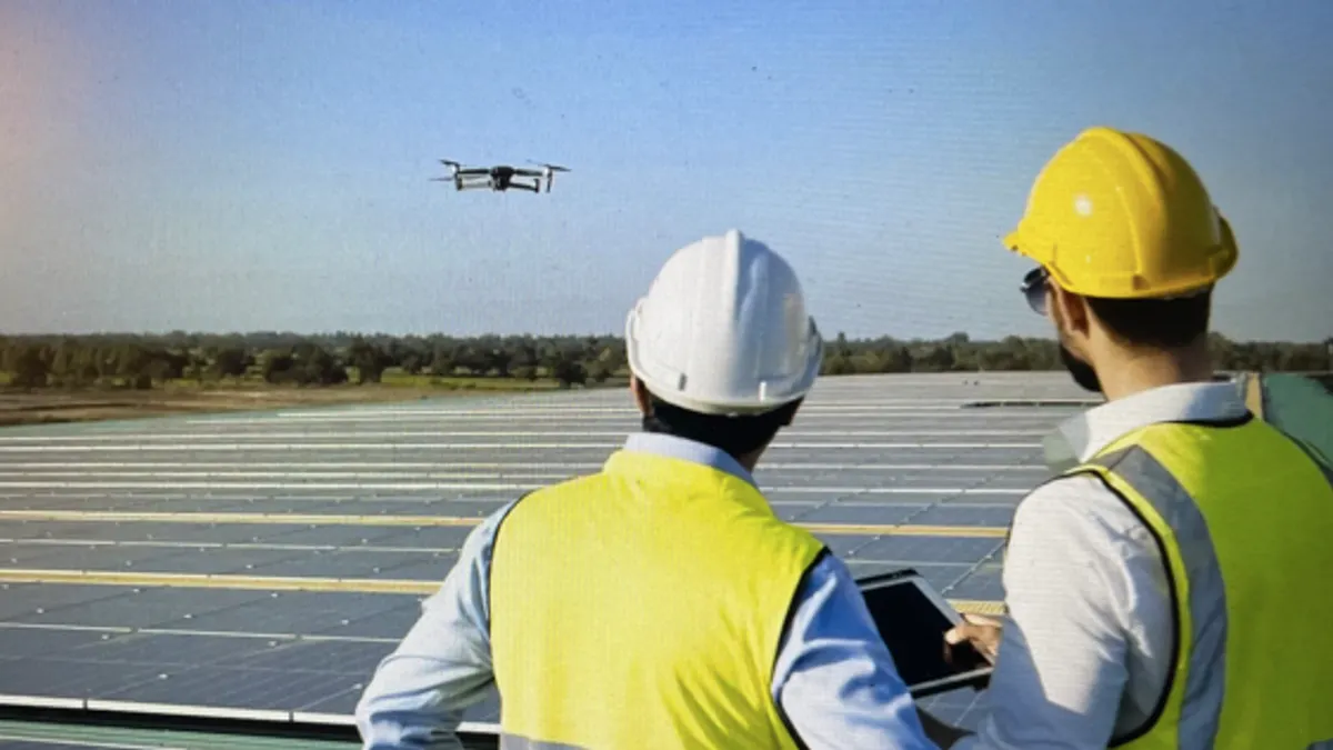
Facility managers wrestling with how to allocate scarce budget resources for maintenance and upgrades across a portfolio of properties can get an objective assessment of what to do, and when, with a tool that uses AI-assisted aerial imaging analysis, say executives whose company offers that kind of tool.
“It’s a way to take a data-driven approach to allocating capital,” Miles Kirkpatrick, chief revenue officer at SITE Technologies, told Facilities Dive. “Typically the way it’s done today is, you’ve got your localized facility managers that just scream really loudly when they need work done. It’s a subjective way to allocate money. This is an objective way: you can have all those facilities ranked so you know exactly where money needs to go.”
SITE launched in 2018. The cloud-based platform uses AI to identify from aerial images problems with a facility’s roofing and pavement areas and it uses a team of engineers to recommend a maintenance and repair plan. By early next year the assessments will expand to include building facades.
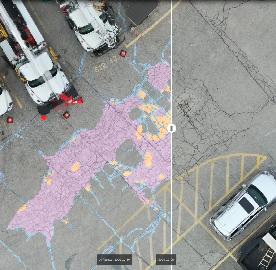
“We use Army Corps of Engineers standards to assign a code that’s widely used in the industry – a pavement condition index, a roof condition index,” said Kirkpatrick. “Our team of in-house engineers use the AI, plus their expertise, to provide a repair plan, then we help the clients manage the work by creating bids to send out to contractors.”
The tool can benefit facility managers overseeing one or a few properties, but the more properties involved, the more cost-effective it can be, the company says.
“There’s definitely more value for the owners who have multiple properties, especially if they’re diverse throughout geographies, because it's more difficult for them to get the data they need,” said Austin Rabine, the company’s co-founder and CEO.
Although the assessments focus on roofing and pavement, the detail of the aerial images and the way the AI is configured makes the tool useful for other purposes, the company says.
“If you ask someone, what is the cumulative roof square footage across your portfolio, many don’t know the answer to that,” said Kirkpatrick. “We very easily can tell you that because we just measure it out for you. Or you ask, ‘How many HVAC units do you have across your portfolio, or what is your percentage of asphalt versus concrete? How many parking spots do you have?’ Just base level information.”
Today, roof or pavement assessments are usually done by contractors that facility managers hire to come out, take pictures and provide recommendations in a report.
“We were talking to a customer two days ago who told us they pay approximately $2,000 a facility to have someone do a roof walk,” said Kirkpatrick. “And then they pay a per diem on top of that for travel and food, so you could be, all-in, $2,200 to $2,600 a building.”
SITE doesn’t own or operate the drones that are deployed for the aerial images. It contracts with operators based near the property. It typically takes 1-2 days to get the flyover completed.
There are almost half a million FAA-certified drone operators, what the FAA calls remote pilots, in the United States, according to the agency.
“Finding the pilot is not necessarily the issue,” said Rabine. “We can get people out on site generally within a day or two.”
If there’s a delay, it typically has to do with airspace restrictions. If the property is near an airport, for example, there needs to be coordination between the airport and the pilot before the flyover can be scheduled. Or the property might be near sensitive government property — a significant issue in the Washington, D.C., metro area, Kirkpatrick said.
Drones aren’t necessary for capturing the aerial shots, the company says. The platform is agnostic on how it gets the imagery. It could be by satellite, manned aircraft or even someone’s cell phone. The drone imagery provides the best quality, though.
“We have customers – the Dallas-Ft. Worth airport and a railway provider – who have their own drone programs,” said Kirkpatrick. “So they’ll capture the data and just send it to us for analysis.”
The company didn’t want to get into the business of owning and operating drones, Rabine said, because there are plenty of companies that do that already. The value-add that SITE brings, he said, is in the AI mapping of the images and in the analysis, which can be done at scale.
“One of the biggest problems we were solving when we started SITE was the ability to assess many sites across the U.S.,” said Rabine. “Now we’re in 15 countries. So, we wanted to use an outsourced data collection tool. Where we come in is in the platform.”
At the corporate level, companies can use the platform on a one-off basis as a due diligence tool when they look at the property as a possible acquisition.
Facility managers can use the platform for one-off projects, too, like inspecting damage to determine the scope of work needed for repairs. But they can get more value by using it for annual inspections so they can track roofing and pavement condition over time, the company says. That way they can rank work priority across their properties and catch degradation before it escalates into a crisis.
“You’re going to have an all-up view of all of your properties,” said Kirkpatrick. “From worst to best, we’re going to stack-rank your properties – tell you exactly where you need to focus your capital.”